Verdugo (river)
Appearance
| Verdugo | |
|---|---|
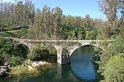
 Medieval bridge over the Río Verdugo in Comboa. | |
| Location | |
| Country | Spain |
| Physical characteristics | |
| Source | |
| • elevation | 760 m (2,490 ft) |
| Mouth | |
• location | Ría de Vigo, Atlantic Ocean |
| Length | 41 km (25 mi) |
| Basin size | 357 km2 (138 sq mi) |
The Verdugo is a river in the province of Pontevedra, Galicia, in north-western Spain. Its source is 760 metres (2,490 ft) above sea level, in the municipality of Forcarei. The river ends in the Atlantic Ocean, at Pontevedra.
See also[edit]
42°21′N 8°37′W / 42.350°N 8.617°W
