Płaska
Appearance
Płaska | |
|---|---|
Village | |
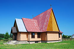
 Chapel in Płaska | |
| Coordinates: 53°54′N 23°15′E / 53.900°N 23.250°E | |
| Country | |
| Voivodeship | Podlaskie |
| County | Augustów |
| Gmina | Płaska |
| Population | 370 |
Płaska [ˈpwaska], (Template:Lang-lt), is a village in Augustów County, Podlaskie Voivodeship, in north-eastern Poland, close to the border with Belarus.[1] It is the seat of the gmina (administrative district) called Gmina Płaska. It lies approximately 20 kilometres (12 mi) east of Augustów and 88 km (55 mi) north of the regional capital Białystok.
The village has a population of 370.

