Knaj
Appearance
Knaj | |
|---|---|
Village | |
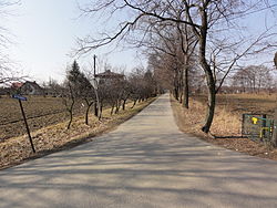
 Main street of the hamlet | |
| Coordinates: 49°52′32″N 18°43′51″E / 49.87556°N 18.73083°E | |
| Country | |
| Voivodeship | Silesian |
| County | Cieszyn |
| Gmina | Strumień |
Knaj [knai̯] is a hamlet of Drogomyśl in the administrative district of Gmina Strumień, within Cieszyn County, Silesian Voivodeship, in southern Poland.[1] It lies approximately 7 kilometres (4 mi) south of Strumień, 16 km (10 mi) north-east of Cieszyn, and 46 km (29 mi) south-west of the regional capital Katowice.
The settlement originated as a folwark (German: vorwerk), mentioned in 1722 as zum vorwerg Knay. It lies on the Knajka stream and on the southern outskirts of Kniejski Las (lit. Knaj's Forest). All this names are derived from a word knieja denoting a wild, dense forest.[2] In 1735 Knaj was adjoined to a Catholic parish in Pruchna. Later it became a part of the modern municipality of Drogomyśl.
References
[edit]- ^ "Central Statistical Office (GUS) - TERYT (National Register of Territorial Land Apportionment Journal)" (in Polish). 2008-06-01.
- ^ Mrózek, Robert (1984). Nazwy miejscowe dawnego Śląska Cieszyńskiego [Local names of former Cieszyn Silesia] (in Polish). Katowice: Uniwersytet Śląski w Katowicach. p. 91. ISSN 0208-6336.

