
Münchsmünster
Münchsmünster | |
|---|---|
 Coat of arms | |
Location of Münchsmünster within Pfaffenhofen a.d.Ilm district  | |
 Münchsmünster  Münchsmünster | |
| Coordinates: 48°45′51″N 11°41′28″E / 48.76417°N 11.69111°E | |
| Country | Germany |
| State | Bavaria |
| Admin. region | Oberbayern |
| District | Pfaffenhofen a.d.Ilm |
| Government | |
| • Mayor | Andreas Meyer |
| Area | |
| • Total | 15.81 km2 (6.10 sq mi) |
| Elevation | 357 m (1,171 ft) |
| Population (2022-12-31)[1] | |
| • Total | 3,183 |
| • Density | 200/km2 (520/sq mi) |
| Time zone | UTC+01:00 (CET) |
| • Summer (DST) | UTC+02:00 (CEST) |
| Postal codes | 85126 |
| Dialling codes | 08402 |
| Vehicle registration | PAF |
| Website | www.muenchsmuenster.de |
Münchsmünster is a municipality in the district of Pfaffenhofen in Bavaria in Germany. The town grew up around the former Münchsmünster Abbey, which was demolished around 1817 and its stones used for construction of houses.
Gallery
-
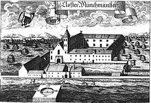 Kloster Muenchsmuenster (1701) by Michael Wening
 -
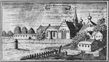 Copperplate engraving of the abbey by Anton Wilhelm Ertl, 1687
 -
 Rauscher guest house
 -
 Forest house
 -
 Church interior
 -
 Gueterbahnhof Industrial park


References
- ^ Genesis Online-Datenbank des Bayerischen Landesamtes für Statistik Tabelle 12411-003r Fortschreibung des Bevölkerungsstandes: Gemeinden, Stichtag (Einwohnerzahlen auf Grundlage des Zensus 2011) (Hilfe dazu).
Towns and municipalities in Pfaffenhofen (district) | ||
|---|---|---|
| International | |
|---|---|
| National | |
This Pfaffenhofen district location article is a stub. You can help Wikipedia by expanding it. |