
Texhomex
Texhomex is a marker showing the tri-point of Oklahoma, Texas and New Mexico. The marker is off U.S. Highway 56 about one mile east on Texas State Line Road and the corner of Oklahoma State Line Road. There are no signs on Highway 56 in either direction.
The tri-state marker is in a pasture and can be accessed by walking over a cattle guard.
-
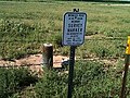 Marker location
 -
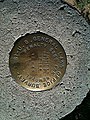 New Mexico top right, Oklahoma bottom right, Texas on the left.

.jpg)
External links
36°30′01.67″N 103°00′08.58″W / 36.5004639°N 103.0023833°W
This article about geography terminology is a stub. You can help Wikipedia by expanding it. |
This New Mexico state location article is a stub. You can help Wikipedia by expanding it. |
This Oklahoma state location article is a stub. You can help Wikipedia by expanding it. |
 | This article about a location in Dallam County, Texas is a stub. You can help Wikipedia by expanding it. |
- Borders of Oklahoma
- Borders of Texas
- Borders of New Mexico
- Buildings and structures in Union County, New Mexico
- Monuments and memorials in Oklahoma
- Buildings and structures in Cimarron County, Oklahoma
- Geography of Dallam County, Texas
- Monuments and memorials in Texas
- Geography of Union County, New Mexico
- Border tripoints
- Monuments and memorials in New Mexico
- Buildings and structures in Dallam County, Texas
- Geography terminology stubs
- New Mexico geography stubs
- Oklahoma geography stubs
- Texas Panhandle geography stubs