Jump to content

Seelingstädt

Coordinates: 50°47′28″N 12°14′33″E / 50.79111°N 12.24250°E / 50.79111; 12.24250
From Wikipedia, the free encyclopedia

This is an old revision of this page, as edited by Kelutral (talk | contribs) at 23:15, 17 August 2018. The present address (URL) is a permanent link to this revision, which may differ significantly from the current revision.

Seelingstädt
Coat of arms of Seelingstädt
Location of Seelingstädt within Greiz district
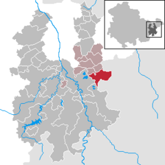
Auma-WeidatalBad KöstritzBergaBethenhausenBockaBrahmenauBraunichswaldeCaaschwitzCrimlaEndschützGauernGreizGroßensteinLangenwetzendorfHarth-PöllnitzHilbersdorfHirschfeldHohenleubenWeidaHundhauptenKauernKorbußenKraftsdorfLangenwetzendorfLangenwolschendorfLederhoseLindaLindenkreuzLangenwetzendorfMohlsdorf-TeichwolframsdorfMünchenbernsdorfLangenwetzendorfPaitzdorfPölzigReichstädtRonneburgRückersdorfSaaraWeidaSchwaaraSchwarzbachSeelingstädtWeidaTeichwitzWeidaWeißendorfLangenwetzendorfWünschendorfZedlitzZeulenroda-TriebesThuringia
Seelingstädt is located in Germany
Seelingstädt
Seelingstädt
Seelingstädt is located in Thuringia
Seelingstädt
Seelingstädt
Coordinates: 50°47′28″N 12°14′33″E / 50.79111°N 12.24250°E / 50.79111; 12.24250
CountryGermany
StateThuringia
DistrictGreiz
Municipal assoc.Wünschendorf/Elster
Subdivisions5
Government
 • MayorRegina Hilbert
Area
 • Total17.97 km2 (6.94 sq mi)
Highest elevation
345 m (1,132 ft)
Lowest elevation
295 m (968 ft)
Population
 (2022-12-31)[1]
 • Total1,282
 • Density71/km2 (180/sq mi)
Time zoneUTC+01:00 (CET)
 • Summer (DST)UTC+02:00 (CEST)
Postal codes
07580
Dialling codes036608
Vehicle registrationGRZ

Seelingstädt is a municipality in the district of Greiz, in Thuringia, Germany. The town has a municipal association with Wünschendorf/Elster.

References

  1. ^ "Bevölkerung der Gemeinden, erfüllenden Gemeinden und Verwaltungsgemeinschaften in Thüringen Gebietsstand: 31.12.2022" (in German). Thüringer Landesamt für Statistik. June 2023.