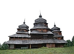
Isai, Ukraine
Appearance
Іsai
Ісаї | |
|---|---|
Village | |
 Saint Michael church (1663) | |
| Coordinates: 49°13′36″N 23°06′51″E / 49.22667°N 23.11417°E | |
| Country | |
| Oblast | Lviv |
| Raion | Turka |
| Area | 4.2 km2 (1.6 sq mi) |
| Population | 939 |
| • Density | 220/km2 (580/sq mi) |
Іsai (Ukrainian: Ісаї, Polish: Isaje) is a village (selo) in Turka Raion, Lviv Oblast, in south-west Ukraine.
The village was first mentioned in 1537. The village boasts an Orthodox church built in 1663.[1]
References
- ^ Rąkowski, Grzegorz (2013). Ukraińskie Karpaty i Podkarpacie. Część zachodnia (in Polish). Pruszków: Oficyna Wydawnicza "Rewasz". p. 446. ISBN 978-83-62460-31-1.
Wikimedia Commons has media related to Isai.


