
Petroglyphs of Sikachi-Alyan
| Petroglyphs of Sikachi-Alyan | |
|---|---|
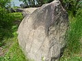
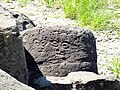
 A stele with a petroglyph on the bank of the Amur | |
 Location within the Khabarovski krai | |
| Location | Sikachi-Alyan, Khabarovsk Krai, Russia |
| Nearest city | Khabarovsk |
Petroglyphs of Sikachi-Alyan are Petroglyphs on basalt rocks located near the Sikachi-Alyan Nanai village (Khabarovski krai, Russia).
The oldest of the Sikachi-Alyan petroglyphs dated to 12000 - 9000 BC. These petroglyphs have been known to local people for many centuries; the first scientific research about these rocks was done in 1859 by Richard Maack.
Pictures of the petroglyphs (the lower group)
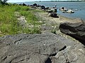
Petroglyphs are located on the Amur river bank downstream from the Sikachi-Alyan village. These rocks are easily accessible for viewing.
-
 Riverbank of Amur near the lower group of petroglyphs
 -
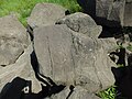
 Engraving of Mammoth
 -
 Mamonth and another creature
 -
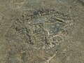
 Shaman
 -
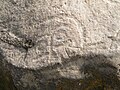
 Mask
Mask -
 Mask
Mask -
 the "Seven sisters"
 -
 the mask of one of the sisters
 -
 The beast with a tail
 -
 Spiral (snail)
 -
 Pattern
 -
 Pattern
 -
 Pattern or mask
 -
 Pattern or mask
 -
 Circles
 -
 Oval with a pattern
 -
 A fish?


Pictures of the petroglyphs (the upper group)
Petroglyphs are located on the Amur river bank upstream from the Sikachi-Alyan village.
-
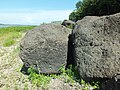
 Riverbank near the upper group
 -
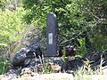 Stella near the upper group
 -
 Big horse
 -
 Small horse
 -
 Pattern
 -
 «Eyes»
 -
 Mask
Mask -
 Human silhouette
 -
 Circles and a Human silhouette
 -
 Elk
Elk -
 Circle and a pattern
 -
 Circles and lines
 -
 Pattern
 -
 Pattern
 -
 Boat?
Boat? -
 Mask
Mask


48°47′56″N 135°43′23″E / 48.7989°N 135.7231°E
This article relating to archaeology in Europe is a stub. You can help Wikipedia by expanding it. |
This Russian history–related article is a stub. You can help Wikipedia by expanding it. |