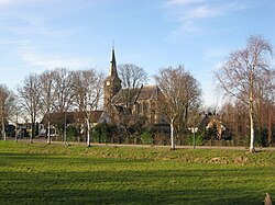
Nederhorst den Berg
Appearance
Nederhorst den Berg | |
|---|---|
 Nederhorst den Berg, 2008 | |
 The statistical district of Nederhorst den Berg in the municipality of Wijdemeren | |
| Coordinates: 52°16′N 5°3′E / 52.267°N 5.050°E | |
| Country | Netherlands |
| Province | |
| Municipality | Wijdemeren |
| Population | |
| • Total | 5,150 |
Nederhorst den Berg (Dutch pronunciation: [ˈneːdərɦɔrst dɛn bɛrx]) is a town in the province of North Holland, Netherlands. It lies about 8 km northwest of Hilversum in the Vechtstreek area, near the Vecht river. Until 1 January 2002, it was a separate municipality; it is now part of the municipality of Wijdemeren.[1]
The statistical district of Nederhorst den Berg, which covers the village and the surrounding countryside, has a population of around 5,100.[2]
References
- ^ Ad van der Meer and Onno Boonstra, Repertorium van Nederlandse gemeenten, KNAW, 2011.
- ^ Statistics Netherlands (CBS), Statline: Kerncijfers wijken en buurten 2003-2005 [1]. As of 1 January 2005.
External links
- Template:Kuyper Map of the former municipality, around 1868.
 Media related to Nederhorst den Berg at Wikimedia Commons

