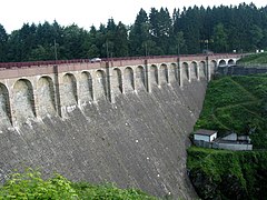
Lake Robertville
Appearance
| Lake Robertville | |
|---|---|
 | |
| Coordinates | 50°27′00″N 06°06′49″E / 50.45000°N 6.11361°E |
| Type | Freshwater artificial lake |
| Basin countries | Belgium |
| Max. length | 3 km (1.9 mi) |
| Max. width | 0.3 km (0.19 mi) |
| Surface area | 0.62 km2 (0.24 sq mi) |
| Max. depth | 54.5 m (179 ft) |
| Water volume | 8,000,000 m3 (6,500 acre⋅ft) |
| Surface elevation | 495 m (1,624 ft) |
| Islands | 0 |
| Settlements | Malmedy |
Lake Robertville is an artificial lake near the city of Malmedy in Belgium in Europe. The water volume is 8,000,000 m³ and the area is 0,62 km². The lake is located in the High Fens park. The dam on the river Warche was built in 1928.
Lake Robertville is situated in the municipality of Waimes. It is named after the village of Robertville.

Wikimedia Commons has media related to Lake Robertville.
