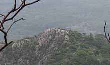
Mount Aduadu
Appearance
| Mount Aduadu | |
|---|---|
 Mount Aduadu as seen from Mount Afadja | |
| Highest point | |
| Elevation | 746 m (2,448 ft) |
| Coordinates | 7°01′08″N 0°34′16″E / 7.01889°N 0.57111°E |
| Geography | |
| Location | Hohoe Municipal District, Volta Region, Ghana |
| Parent range | Agumatsa Range |
Mount Aduadu is the second highest mountain in Ghana, standing at an elevation of 746 metres (2,448 ft). The mountain is located in the Agumatsa Range near the villages of Gblede, Liati Wote and Wli, in the Volta Region of Ghana at the border with Togo.


