
Adelschlag
Adelschlag | |
|---|---|
 Church of Saint Andrew | |
 Coat of arms | |
Location of Adelschlag within Eichstätt district 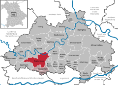 | |
 Adelschlag  Adelschlag | |
| Coordinates: 48°50′N 11°13′E / 48.833°N 11.217°E | |
| Country | Germany |
| State | Bavaria |
| Admin. region | Oberbayern |
| District | Eichstätt |
| Municipal assoc. | Nassenfels |
| Subdivisions | 4 Haupt-Ortsteile |
| Government | |
| • Mayor | Andreas Birzer (CSU) |
| Area | |
| • Total | 51.98 km2 (20.07 sq mi) |
| Elevation | 435 m (1,427 ft) |
| Population (2022-12-31)[1] | |
| • Total | 3,078 |
| • Density | 59/km2 (150/sq mi) |
| Time zone | UTC+01:00 (CET) |
| • Summer (DST) | UTC+02:00 (CEST) |
| Postal codes | 85111 |
| Dialling codes | 08424 |
| Vehicle registration | EI |
| Website | https://www.adelschlag.de/ |
Adelschlag is a municipality in the district of Eichstätt in Bavaria in Germany.
References
- ^ Genesis Online-Datenbank des Bayerischen Landesamtes für Statistik Tabelle 12411-003r Fortschreibung des Bevölkerungsstandes: Gemeinden, Stichtag (Einwohnerzahlen auf Grundlage des Zensus 2011).
Towns and municipalities in Eichstätt (district) | ||
|---|---|---|
|  | |
| International | |
|---|---|
| National | |
| Geographic | |
This Eichstätt district location article is a stub. You can help Wikipedia by expanding it. |