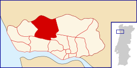
Ramalde
Appearance
Ramalde | |
|---|---|
 | |
| Coordinates: 41°10′08″N 8°38′53″W / 41.169°N 8.648°W | |
| Country | |
| Region | Norte |
| Metropolitan area | Porto |
| District | Porto |
| Municipality | Porto |
| Area | |
• Total | 5.83 km2 (2.25 sq mi) |
| Population (2011) | |
• Total | 38,012 |
| • Density | 6,500/km2 (17,000/sq mi) |
| Time zone | UTC+00:00 (WET) |
| • Summer (DST) | UTC+01:00 (WEST) |
Ramalde (Portuguese pronunciation: [ʁɐˈmaɫd(ɨ)]) is a Portuguese parish of the municipality of Porto. The population in 2011 was 38,012,[1] in an area of 5.83 km².[2]

References
- ^ Instituto Nacional de Estatística (INE), Census 2011 results according to the 2013 administrative division of Portugal
- ^ Áreas das freguesias, concelhos, distritos e país

