Colin (river)
Appearance
| Colin | |
|---|---|
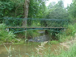
 River at Sainte-Solange | |
| Location | |
| Country | France |
| Physical characteristics | |
| Source | |
| • location | Humbligny |
| Mouth | |
• location | Yèvre |
• coordinates | 47°05′33″N 2°28′11″E / 47.0925°N 2.4696°E |
| Length | 29.1 km (18.1 mi) |
| Basin features | |
| Progression | Yèvre→ Cher→ Loire→ Atlantic Ocean |
The Colin is a 29.1 km (18.1 mi) long[1][2] river in the French department of Cher in central France. It is an tributary of the Yèvre, its waters eventually reaching the sea through the river Loire.
Geography
The river's source is at Humbligny, where it drains La Motte d'Humbligny, the highest point in the Sancerrois region. It runs through Les Aix-d'Angillon and Sainte-Solange and joins the Yèvre at Saint-Germain-du-Puy.
Communes
Humbligny, Morogues, Aubinges, Les Aix-d'Angillon, Sainte-Solange, Saint-Germain-du-Puy,
References
- ^ Sandre. "Fiche (K5564200)". Retrieved 31 July 2015.
{{cite web}}: Cite has empty unknown parameters:|éditeur=and|année=(help) - ^ Sandre. "Fiche ruisseau le colin (K5564201)". Retrieved 21 December 2009.
{{cite web}}: Cite has empty unknown parameters:|éditeur=and|année=(help)
