
Bradshaw Field Training Area
| Bradshaw Field Training Area | |
|---|---|
 Australian Army M1A1 Abrams Tanks during an exercise at the Bradshaw Field Training Area in 2014 | |
| Type | Training area |
| Site information | |
| Owner | Australian Army |
| Site history | |
| In use | 1996–current |
The Bradshaw Field Training Area (BFTA) is a large area in the Northern Territory used for training by the Australian Army as well as an Australia-US Joint Combined Training Centre. The training area is a former cattle station, Bradshaw Station, which was purchased by the Australian Government for military training in 1996. It occupies approximately 870,000 hectares, starting 500 metres north of the settlement of Timber Creek.[1] A large dirt airstrip capable of operating C-17 Globemaster transport aircraft was built by Australian Defence Force and United States Military engineers at BFTA in less than four weeks during Exercise Talisman Sabre in 2007.[2]
-
 Yambarran Ranges, Bradshaw Field Training Area
 -
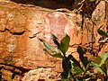 Aboriginal rock art, Inukalen Cataracts
 -
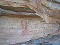 Aboriginal Rock Art, cliff face, Yambarran Plateau
 -
 Ptilotus exaltatus, Angalarri River


Notes
- ^ "Bradshaw Defence Area, Timber Creek, NT, Australia (Place ID 102921)". Australian Heritage Database. Australian Government. Retrieved 20 June 2009.
- ^ AAP (29 June 2007). "New airstrip opens in NT outback". The Sydney Morning Herald. Retrieved 20 June 2009.
References
Wikimedia Commons has media related to Bradshaw Field Training Area.
- Northern Territory Department of Lands, Planning and Environment (1998). "Bradshaw Field Training Area Environment Assessment Report". Northern Territory Government. Archived from the original on 7 October 2009.