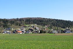
Cesta, Dobrepolje
Appearance
Cesta | |
|---|---|
 | |
| Coordinates: 45°51′37.07″N 14°41′29.12″E / 45.8602972°N 14.6914222°E | |
| Country | |
| Traditional region | Lower Carniola |
| Statistical region | Central Slovenia |
| Municipality | Dobrepolje |
| Area | |
• Total | 4.4 km2 (1.7 sq mi) |
| Elevation | 444.2 m (1,457.3 ft) |
| Population (2002) | |
• Total | 262 |
| [1] | |
Cesta (pronounced [ˈtseːsta]; Template:Lang-de[2]) is a village in the Municipality of Dobrepolje in the historical region of Lower Carniola in Slovenia. The municipality is now included in the Central Slovenia Statistical Region.[3]
A small roadside chapel-shrine in the southern part of the settlement dates to the late 19th century.[4]
References
- ^ Statistical Office of the Republic of Slovenia
- ^ Leksikon občin kraljestev in dežel zastopanih v državnem zboru, vol. 6: Kranjsko. 1906. Vienna: C. Kr. Dvorna in Državna Tiskarna, p. 48.
- ^ Dobrepolje municipal site
- ^ "EŠD 16746". Registry of Immovable Cultural Heritage (in Slovenian). Ministry of Culture of the Republic of Slovenia. Archived from the original on 28 July 2011. Retrieved 28 February 2011.
External links


