Borko, Mali
Appearance
Borko | |
|---|---|
Commune and village | |
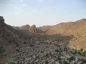
 Borko at sunrise | |
| Coordinates: 14°57′0″N 3°21′14″W / 14.95000°N 3.35389°W | |
| Country | |
| Region | Mopti Region |
| Cercle | Bandiagara Cercle |
| Population (2009 census)[1] | |
| • Total | 5,798 |
| Time zone | UTC+0 (GMT) |
Borko is a village and rural commune in the Cercle of Bandiagara of the Mopti Region of Mali. The village lies on the edge of the Dogon Plateau, 105 km northwest of Mopti and 73 km north-northwest of Bandiagara. In the 2009 census the commune had a population of 6,254. The village is set in a valley, and is only accessible by one entrance.

References
- ^ Resultats Provisoires RGPH 2009 (Région de Mopti) (PDF) (in French), République de Mali: Institut National de la Statistique, archived from the original (PDF) on 2012-09-19.
External links
- Plan de Sécurité Alimentaire Commune Rurale de Borko 2006-2010 (PDF) (in French), Commissariat à la Sécurité Alimentaire, République du Mali, USAID-Mali, 2006, archived from the original (PDF) on 2012-09-17, retrieved 2012-04-25.


