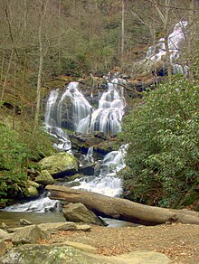
Catawba Falls
| Catawba Falls | |
|---|---|
 Catawba Falls, December 2009 | |
 | |
| Location | McDowell County, in the Blue Ridge Mountains of North Carolina |
| Coordinates | 35°36′14″N 82°14′43″W / 35.603858°N 82.245154°W |
| Type | Cascade |
| Total height | 100 ft (30 m) (estimated) |
| Number of drops | 2 |
| Upper Catawba Falls | |
|---|---|
 Upper Catawba Falls, December 2009 | |
 | |
| Location | McDowell County, in the Blue Ridge Mountains of North Carolina |
| Coordinates | 35°36′14″N 82°14′43″W / 35.603858°N 82.245154°W |
| Type | Cascade |
| Total height | 100 ft (30 m) (estimated) |
| Number of drops | 2 |
Catawba Falls is a series of waterfalls on the headwaters of the Catawba River, in McDowell County, near Old Fort, North Carolina.
Geology
The Catawba River flows over 2 major waterfalls in a short distance. The first drop, called Upper Catawba Falls, consists of an upper free-fall drop, while the second drop a short distance downstream, often called just Catawba Falls, is a higher series of free-falls and cascades.
History
Catawba Falls is part of the Pisgah National Forest. For many years, while the falls were located on public land, visitor access to the falls was heavily restricted. The only access points to the falls were a trail that went through private property, and an access point off of Interstate 40. Use of either access point was illegal.[1]
In 2005 and 2007, the US Forest Service purchased 88 acres (360,000 m2) of land at the end of Catawba River Road for a trailhead. In 2010, access to the falls was officially opened to the public. In 2012, a new parking area was built by the Forest Service.[2] The Forest Service plans further improvements, including a foot bridge over a tricky crossing of the river along the trail and a new trail to the upper falls, bypassing a section considered steep and dangerous.[3] [4]
References
- ^ Adams, Kevin, North Carolina Waterfalls, p. 177
- ^ http://www.fs.usda.gov/detail/nfsnc/news-events/?cid=STELPRDB5363530
- ^ "Archived copy". Archived from the original on 2013-01-29. Retrieved 2010-04-02.
{{cite web}}: CS1 maint: archived copy as title (link) - ^ http://www.ncwaterfalls.com/catawba1.htm
