
Castrisch railway station
Castrisch | |||||
|---|---|---|---|---|---|
 Castrisch station | |||||
| General information | |||||
| Location | Via dalla Staziun 98 7126 Castrisch Surselva, Graubünden Switzerland | ||||
| Coordinates | 46°46′43″N 09°13′59″E / 46.77861°N 9.23306°E | ||||
| Elevation | 705 m (2,313 ft) | ||||
| Owned by | Rhaetian Railway (RhB) | ||||
| Operated by | RhB | ||||
| Line(s) | Landquart - Disentis/Mustér | ||||
| Distance | 40.74 km (25.31 mi) from Landquart | ||||
| History | |||||
| Opened | 1 June 1903 | ||||
| Electrified | 22 May 1922 | ||||
| |||||
| |||||


Castrisch is a railway station on the Reichenau-Tamins–Disentis/Mustér railway of the Rhaetian Railway in the Swiss canton of Graubünden. It serves the village of Castrisch in the municipality of Ilanz/Glion.[1][2]
Services
The station is served by trains on the RE3/R31 services, which provide 1 train per hour in both directions.[2][3]
| Preceding station | Rhätische Bahn | Following station | ||
|---|---|---|---|---|
toward Template:RhB stations | Template:RhB lines | toward Template:RhB stations |
||
| Template:RhB lines | toward Template:RhB stations |
Gallery
-
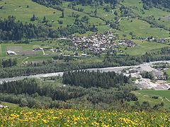 The station can be seen in the centre of the image
 -
 Rail line through Castrisch


References
- ^ "106 - Glarnerland - Bündnerland" (Map). Castrisch railway station (2015 ed.). 1:100 000. National Map 1:100'000. Federal Office of Topography - swisstopo. ISBN 978-3-302-50106-2. Retrieved 2017-06-05 – via map.geo.admin.ch.
- ^ a b "Rail network". Rhaetian Railway. Archived from the original on 2017-06-05. Retrieved 2017-06-05.
- ^ "Chur–Disentis/Mustér–Andermatt" [Official Timetable of Switzerland] (PDF). Offiziellen Kursbuches der Schweiz (in German). Archived (PDF) from the original on 2017-06-06. Retrieved 2017-06-06.
External links
This article about a railway station in Switzerland is a stub. You can help Wikipedia by expanding it. |