Itzgrund
Itzgrund | |
|---|---|
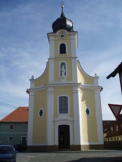
 Saint Wolfgang Church in Kaltenbrunn | |
Location of Itzgrund within Coburg district  | |
| Coordinates: 50°07′N 10°54′E / 50.117°N 10.900°E | |
| Country | Germany |
| State | Bavaria |
| Admin. region | Oberfranken |
| District | Coburg |
| Subdivisions | 6 Ortsteile |
| Government | |
| • Mayor | Werner Thomas (SPD) |
| Area | |
| • Total | 33.08 km2 (12.77 sq mi) |
| Highest elevation | 450 m (1,480 ft) |
| Lowest elevation | 250 m (820 ft) |
| Population (2022-12-31)[1] | |
| • Total | 2,372 |
| • Density | 72/km2 (190/sq mi) |
| Time zone | UTC+01:00 (CET) |
| • Summer (DST) | UTC+02:00 (CEST) |
| Postal codes | 96274 |
| Dialling codes | 09533 teilw. 09573 |
| Vehicle registration | CO |
| Website | www.itzgrund.de |
Itzgrund (valley of the Itz)[2] is a municipality in the district of Coburg in Bavaria in Germany.
References
- ^ Genesis Online-Datenbank des Bayerischen Landesamtes für Statistik Tabelle 12411-003r Fortschreibung des Bevölkerungsstandes: Gemeinden, Stichtag (Einwohnerzahlen auf Grundlage des Zensus 2011) (Hilfe dazu).
- ^ "COBRA DA CAPELLO - COCCUS" Encyclopaedia Americana. A Popular Dictionary of Arts, Sciences. Volume 3 Retrieved 2015-09-06.


