
Terry Badlands WSA
| Terry Badlands WSA | |
|---|---|
  | |
| Location | Prairie County, Montana, USA |
| Nearest city | Terry, MT |
| Coordinates | 46°49′0″N 105°19′0″W / 46.81667°N 105.31667°W |
| Governing body | Bureau of Land Management |
The Terry Badlands WSA (also Terry Badlands) is a designated Wilderness Study Area by the Bureau of Land Management. It is located three miles north of the township of Terry, Montana.
It is part of the National Landscape Conservation System.[1]
-
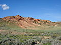 A typical ridgeline in the Terry Badlands WSA.
 -
 View of Terry from the WSA.


See also
References
- ^ "Montana-Dakotas National Conservation Lands". Bureau of Land Management. Retrieved 21 June 2018.
External links
- Official Bureau of Land Management Website
- Custer Country Terry Badlands WSA Website
- Montana magazine article
This Montana-related article is a stub. You can help Wikipedia by expanding it. |