Hanapēpē River
| Hanapēpē River | |
|---|---|
 Swinging bridge across the river in Hanapepe | |
| Location | |
| Country | United States |
| State | Hawaii |
| Physical characteristics | |
| Source | Confluence of the Kō'ula River and Manuahi stream |
| Mouth | Pacific Ocean |
• location | Hanapepe, Hawaii, Eleele, Hawaii |
• coordinates | 21°54′15″N 159°35′29″W / 21.904223°N 159.591522°W |
• elevation | 0 m (0 ft) |
| Length | 5.3 miles (8.5 km) |
| Basin size | 27.7 sq mi (72 km2) |
| Discharge | |
| • location | Below Manuahi stream |
| • average | 85.2 cu ft/s (2.41 m3/s)[1] |
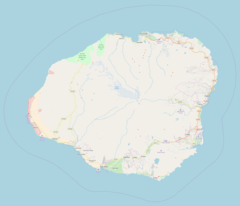
The Hanapepe River is a river on the Hawaiian island of Kauai. It begins at the confluence of the Kō'ula River with the Manuahi Stream and flows generally south for 5.3 miles (8.5 km)[2] to its mouth at Hanapepe and Eleele in the Pacific Ocean.[3] The watershed covers an area of 27.7 square miles, draining roughly a twentieth of the island.[4] The name Hanapepe translates to "crushed bay," which may refer to landslides in the area.[5][6]
The river drains the fertile Hanapepe Valley, a region that was historically used for growing rice, taro, coffee, and sugarcane.[7][8] During the late 19th and early 20th centuries, the valley attracted Chinese, Japanese, Korean, and Filipino immigrant workers, many of whom started their own farms or businesses.[7][9] More recently, the Hanapepe Valley was used for filming parts of the 1993 Steven Spielberg film Jurassic Park.[8]
Near its mouth in Hanapepe, the river passes under the Hanapepe Swinging Bridge. The footbridge was built in 1911 to provide Hanapepe residents with a way to cross the river, and was restored in 1992 after Hurricane Iniki. Considered a local tourist attraction, the bridge is popular with children due to its tendency to rock back and forth.[10]
References
- ^ "USGS Surface-Water Annual Statistics for the Nation". National Water Information System. United States Geological Survey. Retrieved November 17, 2019.
- ^ U.S. Geological Survey. National Hydrography Dataset high-resolution flowline data. The National Map, accessed November 10, 2019
- ^ "Hanapepe River, Kaua'i" (PDF). Hawaii Watershed Atlas. Retrieved November 14, 2019.
- ^ Hanapepe River. "Hanapepe River Topo Map, Kauai County HI (Hanapepe Area)". Topozone.com. Retrieved 2018-01-22.
- ^ Pukui, Mary Kawena. Place Names of Hawaii. University of Hawaii Press. ISBN 0-8248-0524-0.
{{cite book}}: Cite has empty unknown parameter:|coauthors=(help) - ^ University of Hawaii. "Wehewehe". Double click on pēpē, and then doubleclick on pē.pē. University of Hawaii. Retrieved 15 November 2016.
- ^ a b "History". Hanapepe, Hawaii. Retrieved November 13, 2019.
- ^ a b "Hanapepe Valley Lookout". 'imi Tours. Retrieved November 13, 2019.
- ^ Soboleski, Hank (March 17, 2013). "Minehaha, the rice-growing region of Hanapepe Valley". The Garden Island. Retrieved November 13, 2019.
- ^ "Hanapepe Swinging Bridge". Kauai.com. Retrieved November 13, 2019.


