Jump to content

Betioky Sud

Coordinates: 23°43′14″S 44°22′50″E / 23.72056°S 44.38056°E / -23.72056; 44.38056
From Wikipedia, the free encyclopedia

This is an old revision of this page, as edited by 197.159.158.76 (talk) at 21:13, 22 December 2019. The present address (URL) is a permanent link to this revision, which may differ significantly from the current revision.

Betioky
town
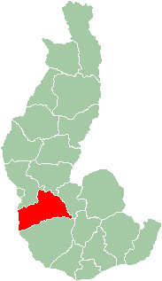
Map of former Toliara Province showing the location of Betioky (red).
CountryMadagascar
RegionAtsimo-Andrefana

Betioky is a town in Atsimo-Andrefana Region, Madagascar and is crossed by the Route nationale 10. An airport serves the town.

Nature

The Beza Mahafaly Reserve lies approx. 35 km North-East of Betioky.

23°43′14″S 44°22′50″E / 23.72056°S 44.38056°E / -23.72056; 44.38056