
Pimentel District
Pimentel | |
|---|---|
 Monument in memory of José Quiñones Gonzales | |
| Country | |
| Region | Lambayeque |
| Province | Chiclayo |
| Founded | October 18, 1920 |
| Capital | Pimentel |
| Government | |
| • Mayor | Cesar Roberto Jacinto Purizaca |
| Area | |
| • Total | 66.53 km2 (25.69 sq mi) |
| Elevation | 4 m (13 ft) |
| Population | |
| • Total | 44,602 |
| • Density | 670/km2 (1,700/sq mi) |
| Time zone | UTC-5 (PET) |
| UBIGEO | 140112 |
Pimentel District is one of twenty districts of the Chiclayo province in Peru. The beach (Playa Pimentel) and reed watercraft caballitos de totora are among its most popular attractions.[1]

Gallery
[edit]-
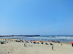 Playa Pimentel, along the Pacific coast.
 -
 Sun setting over Chiclayo Street, Pimentel.
 -
 Not far from the central market in Pimentel.
 -
 The usual slogans for the municipal elections, Pimentel.


References
[edit]- ^ Instituto Nacional de Estadística e Informática. (in Spanish) Banco de Información Distrital Archived 2008-04-23 at the Wayback Machine Retrieved April 11, 2008.
External links
[edit]
| |
|---|---|
| Chiclayo | |
| Ferreñafe | |
| Lambayeque | |
6°50′09″S 79°56′08″W / 6.8359°S 79.9356°W
This Lambayeque Region geography article is a stub. You can help Wikipedia by expanding it. |