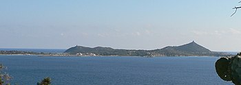
Cape Carbonara
Appearance

Cape Carbonara (Italian: Capo Carbonara) is a promontory of souther-eastern Sardinia, Italy, which forms the eastern end of the Gulf of Cagliari. Together with the nearby Cavoli Island and Serpentara Island, it is included in the Protected Natural Marine Area of Capo Carbonara.
It is situated within the communal territory of Villasimius, c. 6 km from the town's center. The promontory has a length of some 3.5 km and a maximum width of 1.8 km. Sights includes the remains of a fortress on the western side, the Is Traias and Porto Giunco beaches, and the Stagno di Notteri with a colony of pink flamingoes on the eastern side.
The promontory has a beacon.
External links
- Capo Carbonara Protected Area official website (in Italian)
 Media related to Capo Carbonara at Wikimedia Commons
