Waterlooplein metro station
Appearance
Waterlooplein | |||||||||||||||||||
|---|---|---|---|---|---|---|---|---|---|---|---|---|---|---|---|---|---|---|---|
| General information | |||||||||||||||||||
| Location | Waterlooplein, Amsterdam, | ||||||||||||||||||
| Coordinates | 52°22′02″N 4°54′06″E / 52.36722°N 4.90167°E | ||||||||||||||||||
| Owned by | GVB | ||||||||||||||||||
| Line(s) | 9, 14 (Tram) 51, 53, 54 (Metro) | ||||||||||||||||||
| Platforms | 2 | ||||||||||||||||||
| Tracks | 2 | ||||||||||||||||||
| Other information | |||||||||||||||||||
| Fare zone | 5700 (Centrum) | ||||||||||||||||||
| History | |||||||||||||||||||
| Opened | 11 October 1980 | ||||||||||||||||||
| Services | |||||||||||||||||||
| |||||||||||||||||||
Waterlooplein is an Amsterdam Metro station in the centre of Amsterdam, Netherlands. The station is close to the Stopera, the city hall of Amsterdam.
The Station
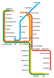
The station opened in 1980 and is served by 3 lines, the 51 (Amsterdam Centraal - Amstelveen), 53 (Amsterdam Centraal - Gaasperplas) and 54 (Amsterdam Centraal - Gein).
The station's location is close to the Waterlooplein, Rembrandt House Museum, the Stopera, Joods Historisch Museum, Hortus Botanicus and Hermitage Amsterdam.
The metro station is only accessible with an OV-chipkaart or GVB Travel Pass.
Tram services
- 9 - Amsterdam Centraal - City Centre - Waterlooplein - Plantage - Watergraafsmeer - Diemen Sniep
- 14 - Sloterpark - Rozengracht - City Centre - Waterlooplein - Plantage - Flevopark

References
Wikimedia Commons has media related to Metrostation Waterlooplein.
- GVB website (in English)
