Baudres
Appearance
Baudres | |
|---|---|
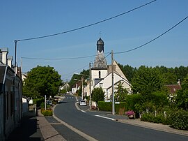
 The church and the main road in the centre of Baudres | |
| Coordinates: 47°03′30″N 1°34′45″E / 47.0583°N 1.5792°E | |
| Country | France |
| Region | Centre-Val de Loire |
| Department | Indre |
| Arrondissement | Châteauroux |
| Canton | Levroux |
| Intercommunality | Région de Levroux |
| Government | |
| • Mayor (2008–2014) | Jean-Roger Reuillon |
| Area 1 | 27.4 km2 (10.6 sq mi) |
| Population (2021)[1] | 409 |
| • Density | 15/km2 (39/sq mi) |
| Time zone | UTC+01:00 (CET) |
| • Summer (DST) | UTC+02:00 (CEST) |
| INSEE/Postal code | 36013 /36110 |
| Elevation | 110–206 m (361–676 ft) (avg. 80 m or 260 ft) |
| 1 French Land Register data, which excludes lakes, ponds, glaciers > 1 km2 (0.386 sq mi or 247 acres) and river estuaries. | |
Baudres is a commune in the Indre département in central France.
Population
| Year | Pop. | ±% |
|---|---|---|
| 1793 | 636 | — |
| 1800 | 646 | +1.6% |
| 1806 | 703 | +8.8% |
| 1821 | 936 | +33.1% |
| 1831 | 866 | −7.5% |
| 1836 | 1,041 | +20.2% |
| 1841 | 1,004 | −3.6% |
| 1846 | 1,026 | +2.2% |
| 1851 | 1,055 | +2.8% |
| 1856 | 1,027 | −2.7% |
| 1861 | 992 | −3.4% |
| 1866 | 1,026 | +3.4% |
| 1872 | 973 | −5.2% |
| 1876 | 942 | −3.2% |
| 1881 | 935 | −0.7% |
| 1886 | 977 | +4.5% |
| 1891 | 943 | −3.5% |
| 1896 | 940 | −0.3% |
| 1901 | 959 | +2.0% |
| 1906 | 977 | +1.9% |
| 1911 | 947 | −3.1% |
| 1921 | 825 | −12.9% |
| 1926 | 836 | +1.3% |
| 1931 | 800 | −4.3% |
| 1936 | 801 | +0.1% |
| 1946 | 834 | +4.1% |
| 1954 | 788 | −5.5% |
| 1962 | 751 | −4.7% |
| 1968 | 655 | −12.8% |
| 1975 | 585 | −10.7% |
| 1982 | 561 | −4.1% |
| 1990 | 507 | −9.6% |
| 1999 | 495 | −2.4% |
| 2009 | 499 | +0.8% |
See also
References
- ^ "Populations légales 2021" (in French). The National Institute of Statistics and Economic Studies. 28 December 2023.
Wikimedia Commons has media related to Baudres.


