Le Lorrain
Appearance
Le Lorrain | |
|---|---|
 The church of Saint-Hyacinthe of Lorrain | |
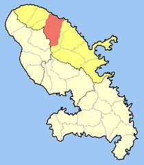
 Location of the commune (in red) within Martinique | |
| Coordinates: 14°50′N 61°04′W / 14.83°N 61.07°W | |
| Country | France |
| Overseas region and department | Martinique |
| Arrondissement | La Trinité |
| Government | |
| • Mayor (2008–2014) | Justin Pamphile |
| Area 1 | 50.33 km2 (19.43 sq mi) |
| Population (2013) | 7,281 |
| • Density | 140/km2 (370/sq mi) |
| Time zone | UTC−04:00 (AST) |
| INSEE/Postal code | 97214 /97214 |
| Elevation | 0–885 m (0–2,904 ft) |
| 1 French Land Register data, which excludes lakes, ponds, glaciers > 1 km2 (0.386 sq mi or 247 acres) and river estuaries. | |
Le Lorrain is a town and commune in the French overseas department of Martinique.
Personalities
See also
References
External links
Wikimedia Commons has media related to Le Lorrain (Martinique).
- Mérimée database - Cultural heritage (in French)

