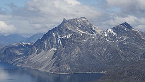
Sermitsiaq Island
Appearance
Sadelø | |
|---|---|
 Aerial view of Sermitsiaq from the southwest | |
| Geography | |
| Location | Nuup Kangerlua |
| Coordinates | 64°18′N 51°27′W / 64.300°N 51.450°W |
| Administration | |
Greenland | |
| Municipality | Sermersooq |
Sermitsiaq Island (Template:Lang-da) is an uninhabited island in the Sermersooq municipality in southwestern Greenland.
Geography
Sermitsiaq is one of three mountainous islands located in the middle section[1] of the 160 km (99.4 mi) long[2] Nuup Kangerlua fjord, to the north of Nuuk, the capital of Greenland. The two sibling islands are Qeqertarsuaq Island and Qoornuup Qeqertarsua Island.[1] The prominent 1,210 metres (3,970 ft)[2] Sermitsiaq mountain topping the island is a landmark of Nuuk, visible from most places in the city.
See also
References
- ^ a b O'Carroll, Etain (2005). Greenland and the Arctic. Lonely Planet. p. 154. ISBN 1-74059-095-3.
- ^ a b "TIL OPPLYSNING". Norwegian University of Science and Technology. Archived from the original on 15 June 2011. Retrieved 15 July 2010.

