
Merville, Haute-Garonne
Merville | |
|---|---|
 The chateau in Merville | |
.svg) Coat of arms | |
Location of Merville  | |
 Merville  Merville | |
| Coordinates: 43°43′21″N 1°17′54″E / 43.7225°N 1.2983°E | |
| Country | France |
| Region | Occitania |
| Department | Haute-Garonne |
| Arrondissement | Toulouse |
| Canton | Léguevin |
| Intercommunality | Save et Garonne |
| Government | |
| • Mayor (2008–2014) | Fernand Bentanax |
| Area 1 | 30.68 km2 (11.85 sq mi) |
| Population (2021)[1] | 6,440 |
| • Density | 210/km2 (540/sq mi) |
| Time zone | UTC+01:00 (CET) |
| • Summer (DST) | UTC+02:00 (CEST) |
| INSEE/Postal code | 31341 /31330 |
| Elevation | 105–179 m (344–587 ft) |
| 1 French Land Register data, which excludes lakes, ponds, glaciers > 1 km2 (0.386 sq mi or 247 acres) and river estuaries. | |
Merville is a commune in the Haute-Garonne department in southwestern France.
Population
| Year | Pop. | ±% |
|---|---|---|
| 1783 | 1,125 | — |
| 1800 | 776 | −31.0% |
| 1806 | 991 | +27.7% |
| 1821 | 1,106 | +11.6% |
| 1831 | 1,117 | +1.0% |
| 1836 | 1,215 | +8.8% |
| 1841 | 1,198 | −1.4% |
| 1846 | 1,287 | +7.4% |
| 1851 | 1,237 | −3.9% |
| 1856 | 1,282 | +3.6% |
| 1861 | 1,285 | +0.2% |
| 1866 | 1,241 | −3.4% |
| 1872 | 1,190 | −4.1% |
| 1876 | 1,181 | −0.8% |
| 1881 | 1,213 | +2.7% |
| 1886 | 1,134 | −6.5% |
| 1891 | 1,136 | +0.2% |
| 1896 | 1,081 | −4.8% |
| 1901 | 1,070 | −1.0% |
| 1906 | 1,047 | −2.1% |
| 1911 | 995 | −5.0% |
| 1921 | 865 | −13.1% |
| 1923 | 873 | +0.9% |
| 1931 | 867 | −0.7% |
| 1936 | 873 | +0.7% |
| 1946 | 872 | −0.1% |
| 1954 | 949 | +8.8% |
| 1962 | 914 | −3.7% |
| 1968 | 1,053 | +15.2% |
| 1975 | 1,365 | +29.6% |
| 1982 | 1,929 | +41.3% |
| 1990 | 2,289 | +18.7% |
| 1999 | 2,796 | +22.1% |
| 2008 | 4,613 | +65.0% |
Monument
-
 Town hall
 -
 War memorial
 -
 Church St Saturnin
 -
 Bell gable
 -
 Nave
Nave -
 Pulpit
 -
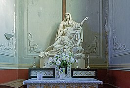
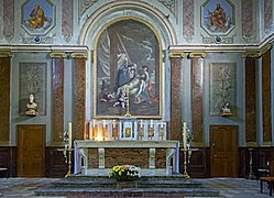 Altar
Altar -


See also
References
- ^ "Populations légales 2021" (in French). The National Institute of Statistics and Economic Studies. 28 December 2023.
Wikimedia Commons has media related to Merville (Haute-Garonne).
| International | |
|---|---|
| National | |
This Haute-Garonne geographical article is a stub. You can help Wikipedia by expanding it. |