
South Street Bridge (Philadelphia, Pennsylvania)
South Street Bridge | |
|---|---|
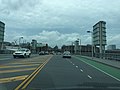
 South Street Bridge with FMC Tower in the background | |
| Coordinates | 39°56′30″N 75°11′52″W / 39.94167°N 75.19778°W |
| Carries | South Street |
| Crosses | Schuylkill River |
| Locale | Philadelphia, Pennsylvania |
| Official name | South Street Bridge |
| Owner | City of Philadelphia |
| Maintained by | Driscoll Construction Company, Inc. - Philadelphia, PA |
| Preceded by | 1920 span |
| Characteristics | |
| Material | Steel, concrete |
| Total length | 753 ft (230 m)[1] |
| Width | 82.7 ft (25.2 m)[1] |
| Longest span | 144 ft (44 m)[1] |
| No. of spans | 7[1] |
| Clearance below | 13.1 ft (4.0 m)[1] |
| History | |
| Designer | H2L2 Architects/Planners, LLC |
| Constructed by | Driscoll Construction Company, Inc. - Philadelphia, PA |
| Construction end | 2010[1] |
| Location | |
 | |
The South Street Bridge is a bridge that was reconstructed in 2010 in Philadelphia, Pennsylvania.
History
The original South Street Bridge was a crumbling bridge dating back to 1920 that from 2003 to 2006 until its closure in 2009, pieces of concrete would fall into the Schuylkill River and onto the Schuylkill Expressway. The original bridge was completely torn down and replaced by November 6, 2010.[2]
Architectural features
The South Street Bridge is notable landmark in Philadelphia as drivers along the Schuylkill Expressway can see images on its "glowing mesh". Bruce Chamberlain said that the mesh "... gave the bridge a soft glow at night, while maintaining the openness desired by the design team and community." [3] Stimulus funding also subsidized connections from the new bridge to a "boardwalk" on the Schuylkill River Trail, which passes under the bridge.[4]
-
 South Street Bridge platform

See also
References
- ^ a b c d e f "South Street over I-76, Schuylkill R & CSX, Philadelphia County, Pennsylvania". bridgereports.com. Source: National Bridge Inventory. Retrieved January 20, 2020.
- ^ "After Two Years, South Street Bridge Re-Opens To Traffic". CBS Philly. 7 November 2010.
- ^ "South Street Bridge".
- ^ "Boardwalk and South Street Ramp".