Klingnauer Stausee
Appearance
| Klingnauer Stausee | |
|---|---|
 | |
| Location | Aargau |
| Coordinates | 47°35′N 8°14′E / 47.583°N 8.233°E |
| Type | reservoir |
| Primary inflows | Aare |
| Primary outflows | Aare |
| Basin countries | Switzerland |
| Max. length | 3 km (1.9 mi) |
| Max. width | 500 m (1,600 ft) |
| Surface area | 1.16 km2 (0.45 sq mi) |
| Max. depth | 8.5 m (28 ft) |
| Surface elevation | 318 m (1,043 ft) |
| Islands | 1 |
| Settlements | Döttingen, Klingnau |
| Designated | 9 November 1990 |
| Reference no. | 507[1] |
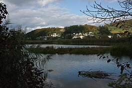
The Klingnauer Stausee (or "Klingnau reservoir") is a reservoir near Böttstein, canton of Aargau, Switzerland, at 47°35′N 8°14′E / 47.583°N 8.233°E. The reservoir with a surface of 1.16 km2 (0.45 sq mi) was formed at the construction of a power plant on the Aare river in the 1930s.[citation needed]
References
- ^ "Klingnauer Stausee". Ramsar Sites Information Service. Retrieved 25 April 2018.
External links
 Media related to Klingnauer Stausee at Wikimedia Commons
- http://www.klingnauerstausee.ch
