Auldgirth
Appearance
| Auldgirth | |
|---|---|
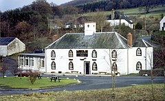
 The Auldgirth Inn, an old coaching Inn on the A76 road. | |
Location within Dumfries and Galloway | |
| OS grid reference | NX9186 |
| Council area | |
| Country | Scotland |
| Sovereign state | United Kingdom |
| Post town | Dumfries |
| Dialling code | 01387 |
| Police | Scotland |
| Fire | Scottish |
| Ambulance | Scottish |
Auldgirth is a village on the A76 road in Dumfries and Galloway, Scotland. Auldgirth village features 'The Auldgirth Inn' and the former Auldgirth Primary School, which closed in 2000.[1] Originally inhabitants of Auldgirth located to the scheme, situated next to the A76, but in recent years this has expanded to the outlying areas due to rejuvenation programmes. The name Auldgirth is from Middle English ald(e) girth, meaning 'old enclosure'.[2] At one time it had a manned railway station, situated one mile south of the village, just before the hamlet of Dalswinton. Carse Loch and the Friar's Carse country house hotel are located nearby.
See also
References
- ^ "Holywood Primary School". Dumfries and Galloway Council. Archived from the original on 17 May 2015. Retrieved 17 May 2015.
- ^ Williamson, May G. (1942). The Non-Celtic Place-names of the Scottish Border Counties (PDF). University of Edinburgh (Unpublished PhD Thesis). p. 115. Archived from the original (PDF) on 21 August 2014.
Wikimedia Commons has media related to Auldgirth.

