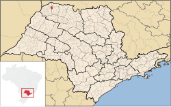
Turmalina
Turmalina | |
|---|---|
Municipality | |
 Location of Turmalina in the state of Minas Gerais | |
| Coordinates: 20°03′07″S 50°28′37″W / 20.052°S 50.477°W | |
| Country | Brazil |
| State | Minas Gerais |
| Municipality | Turmalina |
| Area | |
| • Total | 147.86 km2 (57.09 sq mi) |
| Elevation | 467 m (1,532 ft) |
| Population (2007) | |
| • Total | 2,169 |
| • Density | 15/km2 (38/sq mi) |
| Time zone | UTC−03:00 |
Turmalina is a municipality in the state of São Paulo in Brazil. The population in 2004 was 2,169 and the area is 147.86 square kilometres (57.09 sq mi). The elevation is 467 m.
The municipality contains part of the 5,192 hectares (12,830 acres) Acauã Ecological Station, a fully protected conservation unit created in 1974.[1]
References
- ^ "Estação Ecológica Acauã", Ambiente Brasil (in Portuguese), retrieved 2016-04-27


