
Ingram, Northumberland
| Ingram | |
|---|---|
 View from the car park to the west | |
 Ingram Location within Northumberland | |
| Population | 119 (2011 census)[1] |
| OS grid reference | NU015165 |
| Unitary authority | |
| Ceremonial county | |
| Region | |
| Country | England |
| Sovereign state | United Kingdom |
| Post town | ALNWICK |
| Postcode district | NE66 |
| Dialling code | 01665 |
| Police | Northumbria |
| Fire | Northumberland |
| Ambulance | North East |
| UK Parliament | |
Ingram is a small village in Northumberland, England. It is located in the Cheviots on the River Breamish, and on the edge of Northumberland National Park; it houses a National Park visitor centre.
The village Church of England church is dedicated to St Michael and All Angels.
The Breamish Valley through which the small Breamish river runs is a very popular place with summer visitors and hill walkers. Driving past the visitor centre until coming to the public toilets and car park on the right, one reaches the starting point from which to climb thale hills. Opposite the car park, halfway up the hill towards Brough Law, are the remnants of a Bronze Age settlement, easily missed, as it is merely an overgrown area surrounded by stones. Approximately half an hour is required to walk up the beaten path to the top of Brough Law.
Gallery
-
 The river Breamish at Ingram
 -
 The river next to the car park - popular with kids in the summer


-
 Sheep in the field next to the car park
 -
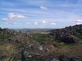 At the top of Brough Law - the nearby hill. It was once an old fort but is now just a circle of tumbled down stones.

-
 The road into the hills - it comes to a dead end

References
- ^ "Parish population 2011". Retrieved 3 July 2015.
External links
- GENUKI (Accessed: 20 November 2008)
This Northumberland location article is a stub. You can help Wikipedia by expanding it. |