Lulworth Camp
Appearance
| Lulworth Camp | |
|---|---|
| Purbeck Hills, Dorset | |
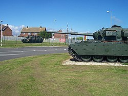
 Tanks on display near the entrance to Lulworth Camp | |
| Coordinates | 50°38′00″N 2°14′00″W / 50.63333°N 2.23333°W |
| Type | Barracks |
| Site information | |
| Owner | Ministry of Defence |
| Operator | |
| Site history | |
| Built | 1918 |
| Built for | War Office |
| In use | 1918-Present |
Lulworth Camp is a British Army base that is home to the Armoured Fighting Vehicle Gunnery School and runs the Lulworth Ranges on the southern coast of Dorset, England. It is part of Bovington Garrison and is located on the Purbeck Ridge between the villages of East and West Lulworth. The camp lies immediately southeast of the road junction between the B 3070 and B 3071 and about a mile northeast of Lulworth Cove.[1]
History
The camp was established in 1918 and has been in continuous use since then.[2]
References
- ^ Ordnance Survey 1:50,000 Landranger map series
- ^ "West Lulworth". Retrieved 11 January 2015.
External links
Wikimedia Commons has media related to Lulworth Camp.

