
Bošilec
Bošilec | |
|---|---|
Municipality | |
 | |
 Bošilec | |
| Coordinates: 49°8′57″N 14°38′46″E / 49.14917°N 14.64611°E | |
| Country | |
| Region | South Bohemian |
| District | České Budějovice |
| Area | |
| • Total | 9.58 km2 (3.70 sq mi) |
| Elevation | 419 m (1,375 ft) |
| Population (2007) | |
| • Total | 206 |
| • Density | 22/km2 (56/sq mi) |
| Postal code | 373 65 |
| Website | http://www.bosilec.cz |
Bošilec is a village and municipality (obec) in České Budějovice District in the South Bohemian Region of the Czech Republic.
The municipality covers an area of 9.58 square kilometres (3.70 sq mi), and has a population of 206 (as at 31 December 2007).
Bošilec lies approximately 24 kilometres (15 mi) north-east of České Budějovice and 106 km (66 mi) south of Prague. There is a song dedicated to the Bošilecký bridge called Na tom bošileckým mostku.
-
 Bošilecký bridge.
 -
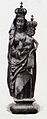 Madonna from Bošilec.

References
Wikimedia Commons has media related to Bošilec.
| International | |
|---|---|
| National | |
This South Bohemian Region location article is a stub. You can help Wikipedia by expanding it. |