
Dolné Orešany
Dolné Orešany | |
|---|---|
Village | |
 | |
 Dolné Orešany Location of Dolné Orešany in the Trnava Region  Dolné Orešany Dolné Orešany (Slovakia) | |
| Coordinates: 48°26′20″N 17°25′41″E / 48.43889°N 17.42806°E | |
| Country | Slovakia |
| Region | Trnava |
| District | Trnava |
| First mentioned | year 1235 |
| Government | |
| • Mayor | Juliana Belicová[1] |
| Area | |
| • Total | 17.890 km2 (6.907 sq mi) |
| Population (2004-12-31) | |
| • Total | 1,334 |
| • Density | 75/km2 (190/sq mi) |
| Postal code | 919 02 |
| Area code | +421-33 |
| Car plate | TT |
| Website | www.dolneoresany.sk |
Dolné Orešany is a village and municipality of Trnava District in the Trnava region of Slovakia.
Gallery
-
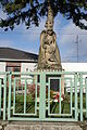 World War I and World War II Memorial
 -
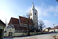 Dolné Orešany Church
 -
 Dolné Orešany Church


See also
References
- ^ statistics.sk. "Zoznam zvolených starostov obcí, primátorov miest a starostov mestských častí". Retrieved 2012-11-05.[permanent dead link]
Genealogical resources
The records for genealogical research are available at the state archive "Statny Archiv in Bratislava, Slovakia"
- Roman Catholic church records (births/marriages/deaths): 1695-1895 (parish A)
- Lutheran church records (births/marriages/deaths): 1666-1895 (parish B)
External links
- www.dolneoresany.sk - official website
Wikimedia Commons has media related to Dolné Orešany.
| International | |
|---|---|
| National | |
This Trnava Region geography article is a stub. You can help Wikipedia by expanding it. |