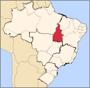
Xambioá, Tocantins
Appearance
Xambioá | |
|---|---|
Municipality | |
 | |
| Country | |
| Region | Northern |
| State | Tocantins |
| Mesoregion | Ocidental do Tocantins |
| Microregion | Araguiana |
| Time zone | UTC -3 |
Xambioá is a municipality in the state of Tocantins in the Northern region of Brazil.[1]
The municipality contains 43% of the 18,608 hectares (45,980 acres) Lago de Santa Isabel Environmental Protection Area, created in 2002.[2]
See also
References
- ^ "IBGE | Cidades | Tocantins | Xambioá". cidades.ibge.gov.br. Retrieved 2016-05-08.
- ^ APA Lago de Santa Isabel (in Portuguese), ISA: Instituto Socioambiental, retrieved 2017-02-08
6°24′39″S 48°32′9″W / 6.41083°S 48.53583°W


