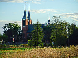
Długosiodło
Długosiodło | |
|---|---|
Village | |
 Saint Roch Church | |
| Coordinates: 52°46′N 21°35′E / 52.767°N 21.583°E | |
| Country | |
| Voivodeship | Masovian |
| County | Wyszków |
| Gmina | Długosiodło |
| Population | 2,020 |
Długosiodło [dwuɡɔˈɕɔdwɔ] is a village in Wyszków County, Masovian Voivodeship, in east-central Poland. It is the seat of the gmina (administrative district) called Gmina Długosiodło.[1] It lies approximately 21 kilometres (13 mi) north-east of Wyszków and 73 km (45 mi) north-east of Warsaw.
History
Długosiodło was the site of the battle between the Duchy of Masovia knights and the combined force representing warriors and knights of Grand Duchy of Lithuania under chief Treniota and Ruthenians of Halych under prince Shvarno. Laden with booty and prisoners from their raid on Masovia (amongst other successes during their 1262 raid, they took the capital of principality Płock, killed prince Siemowit I of Masovia, took his son Konrad II of Masovia prisoner and captured the stronghold of Jazdów, today Ujazdów Warsaw).
Masovian knights lost the Battle of Długosiodło on August 5, 1262.
In September 1939, the Nazis occupied Długosiodło. In October the entire Jewish population was ordered to leave within the hour, abandoning their homes and taking only what they could carry.[2]
The village has a population of 2,020.
References
External links
- Jewish Community in Długosiodło on Virtual Shtetl
52°46′N 21°35′E / 52.767°N 21.583°E


