Wibautstraat metro station
Appearance
Wibautstraat | |||||||||||||||||||
|---|---|---|---|---|---|---|---|---|---|---|---|---|---|---|---|---|---|---|---|
 | |||||||||||||||||||
| General information | |||||||||||||||||||
| Location | Wibautstraat, Amsterdam Netherlands | ||||||||||||||||||
| Coordinates | 52°21′19″N 4°54′41″E / 52.35528°N 4.91139°E | ||||||||||||||||||
| Owned by | GVB | ||||||||||||||||||
| Platforms | 2 | ||||||||||||||||||
| Tracks | 2 | ||||||||||||||||||
| Connections | 3 (300m) (Tram) | ||||||||||||||||||
| Other information | |||||||||||||||||||
| Fare zone | 5700 (Centrum) | ||||||||||||||||||
| History | |||||||||||||||||||
| Opened | 16 October 1977 | ||||||||||||||||||
| Services | |||||||||||||||||||
| |||||||||||||||||||
Wibautstraat is an Amsterdam Metro station in Amsterdam, Netherlands.
The Station
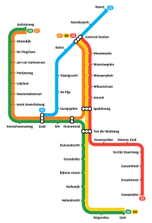
The station opened in 1977 and is served by 3 lines, the 51 (Amsterdam Centraal - Amstelveen), 53 (Amsterdam Centraal - Gaasperplas) and 54 (Amsterdam Centraal - Gein). The station was first planned to be called Oosterparkstraat
The metro station is only accessible with an OV-chipkaart or GVB Travel Pass.
Tram services
Tram 3 departs 300m north of the station on the Ruyschstraat.
- 3 - Zoutkeetsgracht - Frederik Hendrikbuurt - Overtoom - Museumplein - Ceintuurbaan - Wibautstraat - Muiderpoort

References
External links
- GVB Website (in Dutch)
- Online Taxi Reservation
