Runit Island
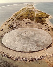
 Satellite view of Runit Island showing the Runit Dome | |
 | |
| Geography | |
|---|---|
| Location | Pacific Ocean |
| Coordinates | 11°32′42″N 162°21′11″E / 11.5450°N 162.3530°E |
| Archipelago | Enewetak Atoll |
| Total islands | 40 |
| Administration | |
| Capital city | Majuro |
Runit Island (/ˈruːnɪt/) is one of 40 islands of the Enewetak Atoll of the Marshall Islands in the Pacific Ocean. The island is the site of a radioactive waste repository left by the United States after it conducted a series of nuclear tests on Enewetak Atoll between 1946 and 1958. There are ongoing concerns around deterioration of the waste site and a potential radioactive spill.[1]
Runit Dome

The Runit Dome, also called Cactus Dome or locally The Tomb, is a 115 m (377 ft) diameter,[2] 46 cm (18 in) thick dome of concrete at sea level, encapsulating an estimated 73,000 m3 (95,000 cu yd) of radioactive debris, including some plutonium-239. The debris stems from nuclear tests conducted in the Enewetak Atoll by the United States between 1946 and 1958.[3][4]
From 1977 to 1980, loose waste and topsoil debris scraped off from six different islands in the Enewetak Atoll was transported here, mixed with concrete, and stored in the nuclear blast crater of the Cactus test from May 6, 1958. Four thousand US servicemen were involved in the cleanup and it took three years to complete. The waste-filled crater was finally entombed in concrete.[5]
In 1982, a US government task force raised concern about a probable breach if a severe typhoon were to hit the island.[6] In 2013, a report by the US Department of Energy[7] found that the concrete dome had weathered with minor cracking of the structure.[8] However, the soil around the dome was found to be more contaminated than its contents, so a breach could not increase the radiation levels by any means. Because the cleaning operation in the 1970s only removed an estimated 0.8 percent of the total transuranic waste in the Enewetak atoll, the soil and the lagoon water surrounding the structure now contain a higher level of radioactivity than the debris of the dome itself, so even in the event of a total collapse, the radiation dose delivered to the local resident population or marine environment should not change significantly. Concern primarily lies in the rapid tidal response to the height of the water beneath the debris pile, with the potential for contamination of the groundwater supply with radionuclides. One particular concern is that, in order to save costs, the original plan to line the porous bottom crater with concrete was abandoned.[3] Since the bottom of the crater consists of permeable soil, there is seawater inside the dome.[3] However, as the Department of Energy report stated, the released radionuclides will be very rapidly diluted and should not cause any elevated radioactive risk for the marine environment, compared to what is already experienced.[7] Leaking and breaching of the dome could however disperse plutonium, a radioactive element that is also a toxic heavy metal.[9][10]
An investigative report by the Los Angeles Times in November 2019 reignited fears of the Dome cracking and releasing radioactive material into the soil and surrounding water.[1][11] The DOE has been directed by Congress to assess the condition of the structure and develop a repair plan during the first half of 2020.[12]
See also
Gallery
-
Runit Island, part of the Enewetak Atoll
-
In 1952, the United States dropped the nuclear bomb Ivy King 610 m (2,000 feet) north of Runit Island.
-
Crater created by detonation on 5 May 1958 (Operation Hardtack I, Cactus test)
References
- ^ a b "How the U.S. betrayed the Marshall Islands, kindling the next nuclear disaster". latimes.com. 10 November 2019. Retrieved 12 November 2019.
- ^ "A Visual Description of the Concrete Exterior of the Cactus Crater Containment Structure" (PDF). October 2013.
- ^ a b c Willacy, Mark (28 November 2017). "A poison in our island". ABC (Australia). Retrieved 28 November 2017.
- ^ Emma Reynolds. "Deadly dome of gorgeous Pacific island leaking radioactive waste", news.com.au, 7 July 2015. Retrieved 12 May 2017.
- ^ "Enewetak". Marshall Islands Dose Assessment & Radioecology Program. 7 April 2015. Retrieved 19 December 2017.
- ^ Michael B. Gerrard (3 December 2014). "A Pacific Isle, Radioactive and Forgotten". The New York Times. Retrieved 4 February 2018.
- ^ a b Visual Description of the Concrete Exterior of the Cactus Crater Containment Structure LLNL-TR-648143
- ^ Jan Hendrik Hinzel, Coleen Jose and Kim Wall. "This dome in the Pacific houses tons of radioactive waste – and it's leaking", The Guardian, 3 July 2015. Retrieved 4 February 2018.
- ^ Mark Willacy (27 November 2017). "The Dome". ABC (Australia). Retrieved 4 February 2018.
- ^ * ABC News documentary, 41min on YouTube
- ^ A Pacific isle radioactive and forgotten, The New York Times, Michael B. Gerrard, December 3, 2014. Retrieved 19 September 2016.
- ^ Mizokami, Kyle. "Nuclear Waste - Runit Dome - Marshall Islands". www.popularmechanics.com. Retrieved 2019-12-28.


