Franklin Local Board
Appearance
Franklin Local Board | |
|---|---|
 | |
| Country | New Zealand |
| Region | Auckland |
| Territorial authority | Auckland |
| Ward | Franklin Ward |
| Legislated | 2010 |
| Government | |
| • Board chair | Andrew Baker |
| Population (June 2023)[1] | |
| • Total | 85,300 |
Local Board Members | |
|---|---|
| Structure | |
Team Franklin | 6 / 9 |
Independent | 2 / 9 |
Waiuku First | 1 / 9 |
| Elections | |
Last election | 2019 |
Next election | 2022 |
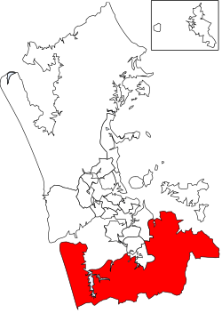
The Franklin Local Board is one of the 21 local boards of the Auckland Council. It is overseen by the Franklin Ward councillor.[2]
The Franklin Local Board area spans the full width of the North Island, from the Hauraki Gulf to the Manukau Harbour. It includes the Hunua Ranges.[2]
Angela Fulljames is the current chair of the board.[3]
2019–2022 term
The board members, elected at the 2019 local body elections, in election order, are:[4]
- Alan Cole, Team Franklin, (5633 votes)
- Andy Baker, Team Franklin, (5166 votes)
- Amanda Kinzett, Team Franklin, (3803 votes)
- Angela Fulljames, Team Franklin, (3546 votes)
- Logan Soole, Team Franklin, (3093 votes)
- Sharlene Druyven, Team Franklin, (3048 votes)
- Malcolm Bell, not affiliated, (2971 votes)
- Lance Gedge, Independent, (2886 votes)
- Matthew Murphy, Waiuku First, (1640 votes)
2016–2019 term
The 2016–2019 board consisted of:
- Angela Fulljames (chair)
- Andy Baker (deputy chair)
- Malcolm Bell
- Alan Cole
- Brendon Crompton
- Sharlene Druyven
- Amanda Hopkins
- Murray Kay
- Niko Kloeten[3]
References
- ^ "Subnational population estimates (RC, SA2), by age and sex, at 30 June 1996-2023 (2023 boundaries)". Statistics New Zealand. Retrieved 25 October 2023. (regional councils); "Subnational population estimates (TA, SA2), by age and sex, at 30 June 1996-2023 (2023 boundaries)". Statistics New Zealand. Retrieved 25 October 2023. (territorial authorities); "Subnational population estimates (urban rural), by age and sex, at 30 June 1996-2023 (2023 boundaries)". Statistics New Zealand. Retrieved 25 October 2023. (urban areas)
- ^ a b "About Local Board". aucklandcouncil.govt.nz. Auckland Council.
- ^ a b "Contact Local Board". aucklandcouncil.govt.nz. Auckland Council.
- ^ "Local board members" (PDF). Auckland Council. 18 October 2019. Retrieved 21 October 2019.
