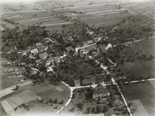
Jump to content

Hegi

Coordinates: 47°30′11″N 8°46′26″E / 47.503°N 8.774°E / 47.503; 8.774
From Wikipedia, the free encyclopedia

This is an old revision of this page, as edited by Tabne (talk | contribs) at 06:31, 22 April 2020 (Aerial view added). The present address (URL) is a permanent link to this revision, which may differ significantly from the current revision.

The quarter of Hegi in Winterthur.

Hegi is a quarter in the district 2 of Winterthur.

It was formerly a part of Oberwinterthur municipality, which was incorporated into Winterthur in 1922.

Aerial view from 300 m by Walter Mittelholzer (1923)

47°30′11″N 8°46′26″E / 47.503°N 8.774°E / 47.503; 8.774