
Camber Railway
| Camber Railway | |
|---|---|
 One of the two 'Wren' class narrow gauge steam locomotives of Camber Railway on the Falkland Islands, 1915. | |
| Overview | |
| Locale | Stanley, Falkland Islands |
| Termini | |
| Stations | none |
| Service | |
| Type | Narrow gauge railway |
| Rolling stock | 2 locomotives and 3 cars[1] |
| History | |
| Opened | 1915[1] |
| Closed | 1920 / 1940[1] |
| Technical | |
| Line length | 5.6 km (3.5 mi) |
| Number of tracks | Single track |
| Track gauge | 2 ft (610 mm)[1] |
The Camber Railway was a 2 ft (610 mm) narrow gauge railway in the Falkland Islands, in the South Atlantic; it was one of the most southerly railways in the world. The Camber Railway was constructed to support the Admiralty wireless station, supplying coal to generators; it ran along the north side of Stanley Harbour for about 3.5 miles (5.6 km).[2][1]
History
There were two Kerr, Stuart and Company "Wren" class 0-4-0 engines.[2][1] The system fell into disuse after the wireless station was modernised. Parts of the infrastructure were used in the Falklands War; rails were taken for use in some defensive structures.[1]
Fleet
- KS "Wren" class steam locomotives - 2 (KS 2388/15 and 2392/15)
- wooden wagon cars - 3
- steam crane (on flat car) - 1
- tipper wagon
- flat car wagon
Gallery
-
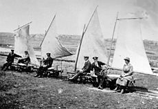
 Camber Railway, 1915-1922. The loco has 'Falkland Island Express' handwritten on the tank. The wooden wagon bodies carry removable seats at each end for workmen. The 1st class, 2nd class, 3rd class, and 'Smoker' legends, not to mention that on the loco's tank, seem to imply that the whole thing was seen as a bit of a joke. The photo was later used on a Falkland Islands 54p stamp.
 -


References
- ^ a b c d e f g "The Camber Railway, Falkland Islands". Britlink.org - British Overseas Territories. Archived from the original on 26 March 2011. Retrieved 16 May 2011.
- ^ a b "11ACamberRly". Railways of the Far South. 6 May 2011. Retrieved 16 May 2011.
External links
Wikimedia Commons has media related to Camber Railway.
- The Camber Railway, Falkland Islands - Britlink
- Railways of the Far South: Falkland Islands and Camber Railway
- (in Spanish) Historias poco conocidas: Un ferrocarril en las Malvinas