Stratená
Appearance
Stratená | |
|---|---|
Village | |
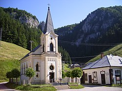
 Church of Saint Augustine | |
| Coordinates: 48°52′N 20°21′E / 48.867°N 20.350°E | |
| Country | Slovakia |
| Region | Košice |
| District | Rožňava |
| Founded | 1723 |
| Area | |
| • Total | 35.36 km2 (13.65 sq mi) |
| Elevation | 860 m (2,820 ft) |
| Population (2004-12-31) | |
| • Total | 140 |
| • Density | 4.0/km2 (10/sq mi) |
| Postal code | 049 72 |
| Car plate | RV |
| Website | http://www.stratena.sk |
Stratená is a village and municipality in the Rožňava District in the Košice Region of middle-eastern Slovakia.
History
In historical records the village was first mentioned in 1723, so it is one of the newest villages in Roznava District.
Geography
The village lies at an altitude of 860 metres and covers an area of 35.361 km². It has a population of about 140 people.
External links

