
Campolieto-Monacilioni railway station
This article needs additional citations for verification. (July 2017) |
Campolieto Monacilioni Railway Station Stazione di Campolieto Monacilioni | |||||
|---|---|---|---|---|---|
 | |||||
| General information | |||||
| Location | Campolieto, Campobasso, Molise Italy | ||||
| Coordinates | 41°38′33″N 14°45′56.52″E / 41.64250°N 14.7657000°E | ||||
| Operated by | Rete Ferroviaria Italiana | ||||
| Line(s) | Termoli-Campobasso Termoli–Venafro | ||||
| Platforms | 2 | ||||
| Tracks | 2 | ||||
| Train operators | Trenitalia | ||||
| Other information | |||||
| Classification | Bronze | ||||
| History | |||||
| Opened | 1883 | ||||
| Electrified | no | ||||
| |||||


The Campolieto-Monacilioni Railway station is the train station that serves the municipalities of Campolieto and Monacilioni, is situated in the Campolieto territory.[1]
-
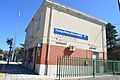 FS train station Campolieto Monacilioni

References
Wikimedia Commons has media related to Campolieto-Monacilioni train station.
- ^ "Stazioni servite da Trenitalia" [Stations served by Trenitalia]. Trenitalia (in Italian). 2018. Archived from the original on 4 August 2018.
- Rif.Legge Baccarini(L. 29 luglio 1879, n. 5002), Relazione statistica sulle costruzioni e sull'esercizio delle strade ferrate italiane per l'anno 1882 (1883). Ministero Dei Lavori Pubblici. Direzione Generale Delle Strade Ferrate (in Italian). Rome: Tipografia Eredi Botta, 1883. p. 116. Retrieved 22 May 2017.
{{cite book}}: CS1 maint: numeric names: authors list (link) - This article is based upon a translation of the Italian language version as at May 2017.
This article about an Italian railway station is a stub. You can help Wikipedia by expanding it. |