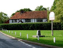
Langenhoe
Appearance

Langenhoe is a village in the Colchester district of Essex, England to the south of Colchester. According to the 2001 census it had a population of 536, increasing to 572 at the 2011 Census.[1]
The village church was once reputed to be amongst the most haunted buildings in Essex.[2] This ancient church, which had been damaged in the Essex earthquake of 1884,[3] was closed to worship in 1955 and demolished in 1963 after it was deemed structurally unsafe.
The name Langenhoe is from the Old English for ‘long hill-spur’.[4]
References
- ^ "Parish populations 2011". Retrieved 29 September 2015.
- ^ Adams, Paul (2014-10-29). "Ten places to spot ghosts this Hallowe'en". ISSN 0307-1235. Retrieved 2018-03-19.
- ^ "MEMORIES: Postcard images show damage caused by the 'Colchester Earthquake'". Gazette. Retrieved 2018-03-19.
- ^ Mills, Anthony David (2003). A dictionary of British place-names. Mills, A. D. (Anthony David), 1935-. Oxford: Oxford University Press. ISBN 0198527586. OCLC 59290127.
External links
- Langenhoe in the Domesday Book
51°49′41″N 0°54′40″E / 51.828°N 0.911°E
