Leadville, New South Wales
Appearance
| Leadville New South Wales | |
|---|---|
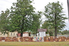
 Norman Horne Memorial Park | |
| Coordinates | 32°00′S 149°33′E / 32.000°S 149.550°E |
| Population | 186 (2006 census)[1] |
| Postcode(s) | 2844 |
| Location |
|
| LGA(s) | Warrumbungle Shire |
| State electorate(s) | Barwon |
| Federal division(s) | Parkes |
Leadville is a town in New South Wales, Australia. The town is located in the Warrumbungle Shire local government area, 376 kilometres (234 mi) north west of the state capital, Sydney. At the 2006 census, Leadville and the surrounding area had a population of 186.[1]
See also
- Denison Town, nearby ghost town
References
Wikimedia Commons has media related to Leadville, New South Wales.
- ^ a b Australian Bureau of Statistics (25 October 2007). "Leadville (State Suburb)". 2006 Census QuickStats. Retrieved 4 April 2009.

