Storebjørn
Appearance
| Storebjørn | |
|---|---|
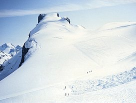
 Summit seen from the north. | |
| Highest point | |
| Elevation | 2,222 m (7,290 ft) |
| Prominence | 800 m (2,600 ft) |
| Coordinates | 61°32′53″N 8°8′14″E / 61.54806°N 8.13722°E |
| Geography | |
 | |
| Location | Lom, Innlandet, Norway |
| Parent range | Jotunheimen |
| Topo map | 1518 II Galdhøpiggen |
| Climbing | |
| First ascent | 14 August 1884, Carl Christian Hall and Mathias Soggemoen |
Storebjørn (literally Big Bear) is a mountain in Lom, Innlandet, Norway and lies in the Jotunheimen mountain range. North of the summit is the mountain Veslebjørn, and east of the glacier Smørstabbrean.
